
Groundwater Investigation (Electrical Resistivity Survey / VES) Services in Namsai, Arunachal Pradesh by Dibru Enterprises…
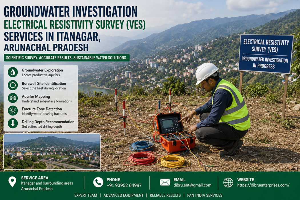
Groundwater Investigation in Itanagar: Electrical Resistivity Survey (VES) Services
Introduction to Groundwater Challenges in Itanagar
Securing a dependable water source in Itanagar, the capital of Arunachal Pradesh, presents a unique set of hydrogeological challenges. The rugged eastern Himalayan terrain features a complex mix of steep hills, fractured rock formations, and narrow river valleys. Because surface water flow fluctuates drastically between the heavy monsoon season and the dry winter months, tapping into sustainable underground aquifers has become an absolute necessity for residential complexes, commercial establishments, public infrastructure development, and agricultural projects.
Locating water beneath this highly variable terrain requires sophisticated scientific intervention rather than guesswork. Drillings wells blindly in mountainous regions frequently leads to dry holes, financial loss, and logistical frustration.
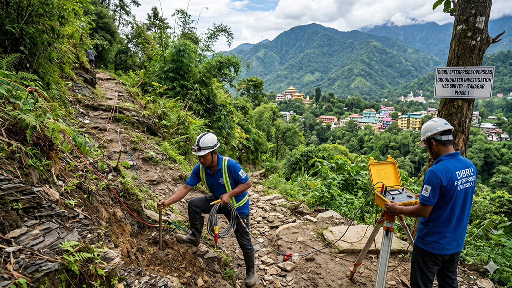
Dibru Enterprises Overseas, based in Guwahati, Assam, bridges this gap by providing professional groundwater investigation services across Itanagar. Utilizing advanced geophysical techniques like Vertical Electrical Sounding (VES), our team maps the subsurface layer by layer. This scientific approach ensures that your borewell or tube well project is backed by accurate data, maximizing your chances of hitting a high-yield, long-term water source.
Understanding Electrical Resistivity Survey and VES
An Electrical Resistivity Survey is a geophysical method used to determine the subsurface resistivity distribution by making measurements on the ground surface. Subsurface materials—such as dry sand, clay, saturated gravel, and solid bedrock—each conduct electricity differently. By introducing a controlled electrical current into the ground and measuring the resulting potential difference, geophysicists can map these variations and identify water-bearing zones.
The Mechanics of Vertical Electrical Sounding (VES)
Vertical Electrical Sounding, commonly known as VES, is a specific type of resistivity survey focused on revealing vertical changes in geological strata.
- Electrode Configuration: The process typically employs a four-electrode array, such as the Schlumberger or Wenner configuration. Two electrodes inject the electrical current into the ground, while the other two measure the potential voltage drop.
- Depth Penetration: Field technicians gradually increase the spacing between the current electrodes. Spacing them farther apart allows the electrical current to penetrate deeper into the earth, providing a clear vertical profile of the subsurface layers.
- Data Interpretation: The measured apparent resistivity is plotted against electrode spacing to create field curves. These curves are processed using specialized inversion software to determine the exact depth, thickness, and nature of the underlying geological formations.
For groundwater exploration, VES is highly effective because water-saturated formations display significantly lower resistivity compared to dry, compact rock or empty fractures. This clear contrast allows our engineers to pinpoint precisely where the water table sits and estimate the thickness of the potential aquifer.
Hydrogeology of Itanagar: How Terrain Influences Investigation
The geological landscape of Itanagar is far from uniform. The city and its surrounding areas features a transition from the foothill plains to rugged mountainous zones. Designing a successful groundwater investigation requires adapting the VES methodology to these distinct terrain types.
-
Hilly and Steep Terrains
Conducting surveys along the steep slopes of Itanagar requires careful physical and mathematical adjustments. Heavy vegetation and sharp inclines make laying out straight electrode lines exceptionally difficult.
From a hydrogeological standpoint, rain running off steep hills prevents deep infiltration, meaning shallow water tables are rarely permanent. Instead, water migrates downwards via structural pathways. Our team looks for localized structural depressions or perched aquifers where water gets trapped above impermeable layers. When managing steep profiles, we apply geometric correction factors to the VES data to compensate for the slope, ensuring the calculated depths remain highly accurate.
-
Fractured Rocky Zones
Much of Arunachal Pradesh is underlain by hard, consolidated rock formations including quartzites, schists, and gneisses. Solid bedrock possess nearly infinite electrical resistivity and holds virtually no water.
Groundwater in these environments is strictly confined to secondary porosity features, such as fractures, joints, shear zones, and faults. Our resistivity surveys focus on locating these structural anomalies. A sudden drop in resistivity within a massive rock block signals a fractured zone filled with water. Finding these hidden structural features requires high-density measurements and precise electrode placement.
-
Plain Areas and River Valleys
The lower elevations and river valleys around Itanagar present an entirely different structural environment. These zones consist of unconsolidated sedimentary deposits, including thick layers of sand, gravel, silt, and clay washed down from the mountains.
Unconsolidated valleys generally offer the highest groundwater potential, but they also demand careful differentiation. Clay layers exhibit very low resistivity, which can easily be mistaken for water-bearing gravel zones by inexperienced operators. Our experienced geophysicists analyze the precise signature of the resistivity curves to distinguish between a tight, non-yielding clay bed and a highly porous, productive sand-and-gravel aquifer.
The Step-by-Step Field Process by Dibru Enterprises Overseas
Executing a reliable groundwater survey involves a rigorous, systematic process that combines historical analysis, physical field measurement, and digital processing.
Phase 1: Desk Study and Geomorphological Analysis
Before setting foot in Itanagar, our engineering team studies regional geological maps, satellite imagery, and historical records of existing local wells. Understanding the regional structural trends allows us to identify promising target zones and plan the field layout efficiently.
Phase 2: Site Reconnaissance
Once on-site, our technicians evaluate the specific topography and clear path lines for the survey layout. We identify potential sources of electrical interference, such as buried metal pipes, high-voltage overhead power lines, or reinforced concrete structures, which could distort the resistivity readings.
Phase 3: Layout and Electrode Planting
The team lays out the survey line using a designated array configuration. Steel electrodes are driven firmly into the ground. In dry or rocky soil where electrical contact resistance is high, we apply a saline solution around the electrodes to ensure an optimal electrical connection with the earth.
Phase 4: Data Acquisition
Using precision resistivity meters, we systematically inject current and record voltage data at expanding electrode intervals. We review data quality in real-time on the field. If unusual spikes or irregular data points appear, we immediately verify electrode contacts and rerun the measurement to guarantee data integrity.
Phase 5: Computational Modeling and Interpretation
The field data is transferred to our engineering hub in Guwahati for advanced processing. We utilize professional geophysical inversion software to transform the raw apparent resistivity curves into a detailed, layered cross-section of the earth. This reveals the exact depths of the soil cover, weathered rock, fractured zones, and solid bedrock basement.
Why Soil Testing and Geotechnical Expertise Matter
Groundwater exploration cannot be fully separated from the broader science of soil and rock mechanics. Because Dibru Enterprises Overseas maintains extensive expertise in comprehensive soil testing services all over India, we bring a deeper layer of engineering insight to every groundwater investigation.
An accurate understanding of soil compaction, grain size distribution, and bedrock depth dictates how water moves through the subsurface. For instance, highly permeable soils allow rapid groundwater recharge, whereas dense, cohesive soils act as barriers. Our dual expertise ensures that when we identify a water-bearing zone, we also evaluate the stability of the overlying soil strata. This comprehensive assessment helps prevent structural borehole collapse during drilling and ensures a stable, long-term well design.
Advantages of Conducting a VES Survey Before Drilling
Investing in a scientific groundwater survey prior to mobilization offers significant technical and financial advantages for any project developer in Itanagar:
- Minimizes Drilling Risks: Drastically reduces the financial risk of drilling “dry holes” in complex mountainous or rocky terrains.
- Determines Optimum Drilling Depth: Identifies exactly where the aquifer begins and ends, allowing you to contract drilling rigs for a precise target depth rather than paying for unnecessary footage.
- Guides Well Construction: Provides essential structural details regarding the depth of loose overburden material, indicating exactly where solid steel or PVC casing pipes must be installed to prevent well collapse.
- Saves Time and Capital: Optimizes resource allocation by focusing construction machinery exclusively on high-probability target locations.
Technical Comparison of Groundwater Environments
| Terrain Category | Primary Geological Composition | Expected Water-Bearing Structures | VES Geophysical Signature | Drilling Considerations |
| Hilly Slopes | Weathered overburdens, colluvium, tilted rock strata | Perched water tables, localized structural depressions | Highly variable curves; localized low-resistivity zones | Risk of surface rig instability; requires deep casing through loose slope debris |
| Rocky Terrains | Quartzite, schist, granite gneiss basement | Fractures, faults, highly jointed bedrock zones | Sharp drop in resistivity within a high-resistivity block | Requires heavy-duty DTH (Down-the-Hole) hammer drilling equipment |
| Valley Plains | Alluvial sand, silt, gravel layers, clay lenses | Unconsolidated porous gravel and sand aquifers | Smooth, continuous low-to-medium resistivity signatures | Standard rotary drilling tools; requires precise screen placement to avoid siltation |
Strategic Significance for Itanagar’s Development
As Itanagar expands its urban footprint—from infrastructure expansions in Zero Point and Ganga Market to new institutional projects near Rajiv Gandhi University—the demand for reliable water utilities continues to surge. Large-scale construction sites require substantial, uninterrupted water volumes for concrete mixing, dust suppression, and worker camps.
Relying on erratic surface water transport via tankers is both financially unsustainable and logistically vulnerable to landslides along hilly roads. Establishing independent, high-yield onsite borewells provides projects with total operational self-sufficiency. By utilizing our localized VES services, regional developers, municipal planners, and private property owners can secure reliable water infrastructure built to withstand seasonal climate shifts.
Choosing Dibru Enterprises Overseas
Partnering with Dibru Enterprises Overseas gives you access to a regional team that understands the distinct environmental conditions of Northeast India. While our corporate foundation is located nearby in Guwahati, Assam, our operational capability spans across the rugged terrains of Arunachal Pradesh.
Regionally Adapted Solutions
We engineer our exploration equipment and field logistics specifically to navigate the steep climbs, dense jungle overburdens, and remote transport routes typical of Itanagar. Our proximity allows us to deploy mobilization teams rapidly, maintaining clear communication channels from project kickoff to final delivery.
Data-Driven Engineering
We deliver clear, professional engineering reports rather than ambiguous summaries. Our documentation outlines calculated layer configurations, interpreted lithology, explicit depth recommendations for drilling, and estimates regarding potential water yield.
Scalable Project Capability
Our nationwide experience in advanced soil testing and geotechnical investigation allows us to manage projects of any scale. Whether you need a single residential well point in a hilly neighborhood or a comprehensive grid-based groundwater assessment for an industrial complex, we provide the technical depth required to ensure success.
Connect with Our Engineering Team
Protect your upcoming drilling infrastructure investment from unpredictable subsurface risks. Let our geophysical exploration specialists provide the data validation your project needs. Reach out to Dibru Enterprises Overseas to discuss your site requirements, request a formal technical proposal, or schedule an on-site field assessment in Itanagar.
- Office Headquarters: Guwahati, Assam
- Direct Line: +91 93952 64997
- Email Communication: dibru.ent@gmail.com
- Official Web Platform: https://dibruenterprises.com/
Related Posts

This Post Has 0 Comments