
Groundwater Investigation (Electrical Resistivity Survey / VES) Services in Namsai, Arunachal Pradesh by Dibru Enterprises…
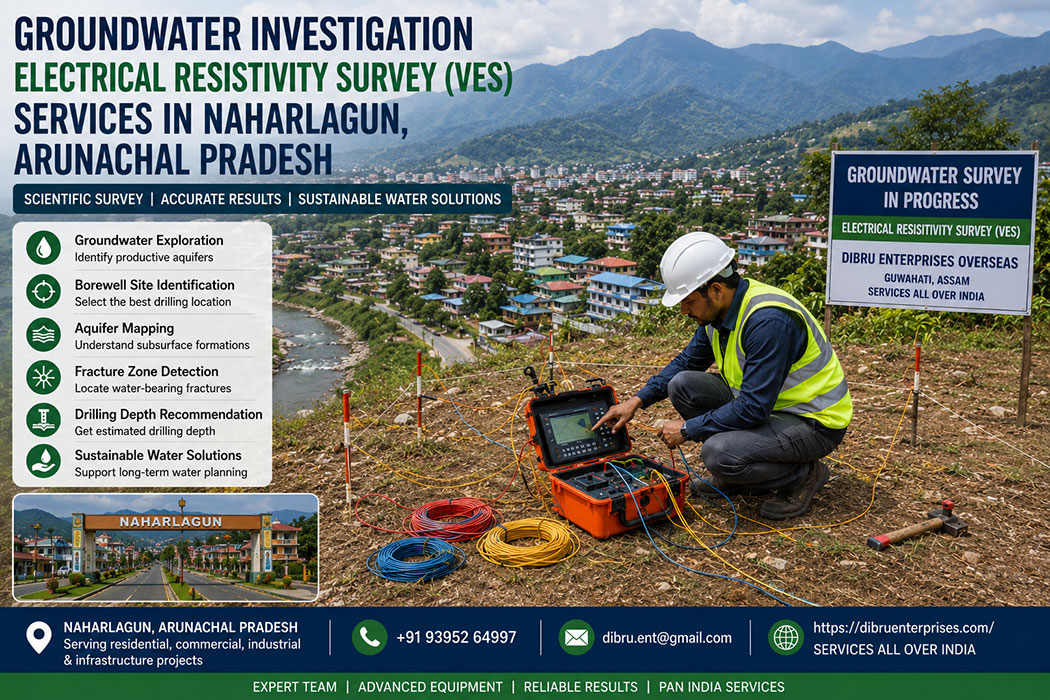
Groundwater Investigation in Naharlagun: Electrical Resistivity Survey (VES) Solutions
The Critical Need for Scientific Water Sourcing in Naharlagun
Establishing a dependable and sustainable water supply in Naharlagun, the bustling twin city of Itanagar in Arunachal Pradesh presents a formidable engineering challenge. Situated along the banks of the Dikrong River and surrounded by the rugged foothills of the Outer Himalayas, this rapidly growing urban and commercial hub faces massive seasonal water fluctuations.
While the monsoon season brings torrential rainfall, the dry winter months lead to a rapid drop in surface water levels and shallow water tables. As infrastructure expands, relying blindly on surface water or traditional digging methods is no longer a viable option for commercial complexes, industrial plants, residential projects, or government installations.
Locating a productive, long-term aquifer beneath Naharlagun’s highly complex geological terrain requires deep scientific intervention. Subsurface conditions here change rapidly across short distances, moving from soft river silt to dense, impenetrable bedrock. Attempting to drill a borehole without precise subsurface data frequently results in dry wells, structural collapses, and massive financial waste.
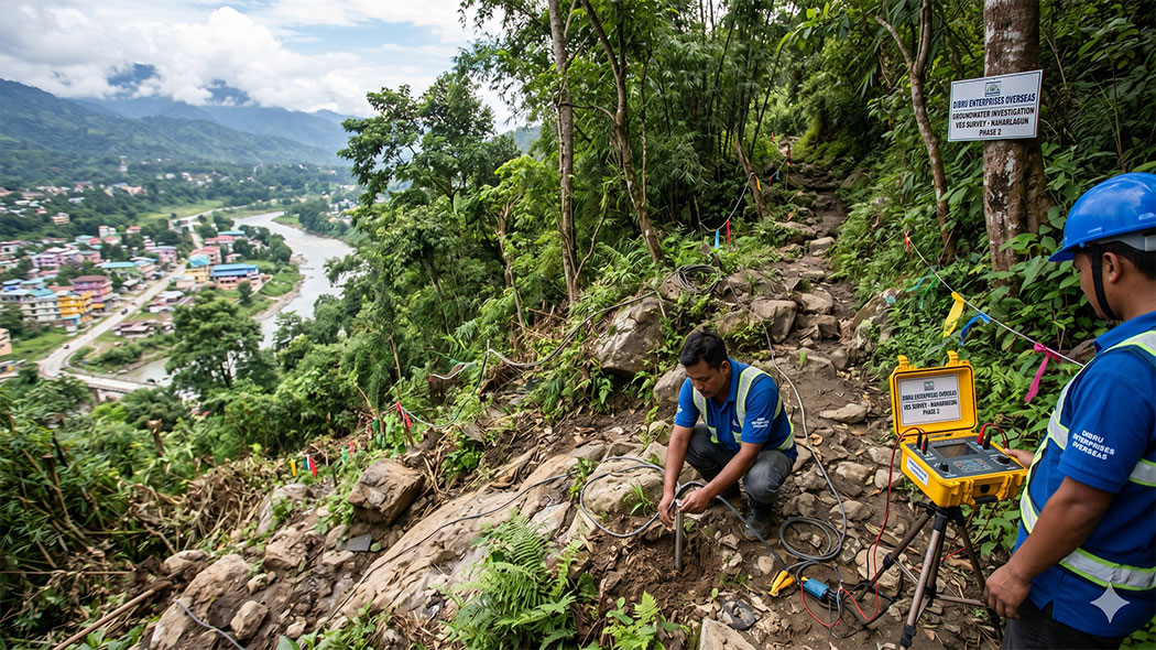
Dibru Enterprises Overseas, based in Guwahati, Assam, addresses these challenges directly by offering expert groundwater investigation services across Naharlagun. Utilizing advanced geophysical methods, specifically Vertical Electrical Sounding (VES), our engineering teams map the underlying geological strata with high precision. This data-driven approach removes the guesswork from water exploration, giving developers the precise information required to drill with total confidence.
Decoding the Science: Electrical Resistivity and the VES Framework
An Electrical Resistivity Survey operates on a fundamental principle of physics: different earth materials offer varying degrees of resistance to an applied electrical current. For instance, compact solid rock acts as an insulator, showing very high resistance. Conversely, clay holds water tightly but exhibits low resistivity due to its mineral composition, while porous sand and gravel formations filled with fresh water display a distinct, highly identifiable intermediate resistivity signature.
The Mechanics of Vertical Electrical Sounding (VES)
Vertical Electrical Sounding, or VES, is a depth-focused geophysical technique designed to chart the vertical sequence of geological layers beneath a single point on the surface.
- The Electrode Array: Field engineers typically set up a four-electrode system using either the Schlumberger or Wenner configuration. Two outer electrodes introduce a controlled direct current (or low-frequency alternating current) into the ground, while two inner electrodes measure the resulting potential voltage drop across the subsurface.
- Deep Layer Penetration: The field crew systematically increases the distance between the current electrodes around a fixed central point. Expanding this footprint forces the electrical current to travel deeper into the earth, capturing resistivity data from progressively deeper geological formations.
- Apparent Resistivity Calculations: The data acquisition system calculates the “apparent resistivity” for each expanding interval. This raw data is plotted on log-log graphs to generate specialized field curves reflecting the subsurface layering.
- Advanced Computer Inversion: Back at our engineering hub, geophysicists process these field curves using advanced inversion software. The software translates electrical data into a clear, physical cross-section showing the exact depth, thickness, and geological characteristics of each layer.
For groundwater sourcing, VES stands out as an exceptionally reliable method. It clearly differentiates between dry, non-porous rock zones and the water-saturated fractured zones or gravel beds that make ideal targets for high-yield borewells.
Naharlagun’s Hydrogeological Landscape: How Terrain Shifts the Survey
The subsurface environment of Naharlagun is distinctly shaped by its position along the Dikrong River basin and the adjacent steep Himalayan foothills. Designing an effective resistivity survey requires adjusting the field methodology to match three primary local terrain types.
-
The Dikrong River Floodplains and Alluvial Terraces
The lower, flatter zones of Naharlagun consist largely of unconsolidated alluvial deposits transported by the river system over millennia. These areas are characterized by alternating beds of coarse gravel, boulders, sand, silt, and thick clay lenses.
While these valley zones generally hold high groundwater potential, they present unique diagnostic challenges. Fine-grained clay layers show a highly conductive, low-resistivity signature that can easily trick an inexperienced operator into misidentifying it as a massive water-yielding aquifer. Our experienced geophysicists carefully analyze the exact slope and shape of the VES curves. This precise interpretation allows us to differentiate between a tight, low-yield clay pocket and a highly permeable, water-bearing sand-and-gravel formation capable of supporting a commercial-grade tube well.
-
The Boulder-Strewn Foothill Zones
Moving away from the active riverbed brings you to the transitional foothill zones, where the ground is dominated by massive boulder beds and highly unsorted colluvium material washed down from the slopes.
Establishing solid electrical contact in boulder-heavy terrain is notoriously difficult. Air gaps between dry boulders block the flow of electrical current, resulting in highly distorted field data. To overcome this obstacle, our field crews use specialized long, heavy-duty steel electrodes. We apply dense saline solutions or conductive gels around the insertion points. This step lowers contact resistance, ensuring the electrical current penetrates deep into the true underlying formations rather than scattering across the surface boulders.
-
The Steep, Fractured Rocky Outcrops
The elevated perimeters of Naharlagun feature hard, consolidated sedimentary and metamorphic rock formations, including highly compacted sandstones and shales. In these solid formations, groundwater cannot exist in the rock matrix itself because there is no primary porosity.
Water in these environments is strictly confined to secondary structures like faults, fractures, joints, and shear zones. Our VES profiles in these areas are strategically deployed to locate sudden, localized drops in resistivity within an otherwise highly resistive rock mass. These sharp drops indicate a water-bearing fracture zone. Pinpointing these hidden targets requires high-density spacing and precise alignment along known structural trends.
Systematic Field Execution: The Dibru Enterprises Protocol
A dependable groundwater investigation relies on a structured, step-by-step methodology that blends historical data analysis with rigorous field safety and technical standards.
Step 1: Pre-Field Desk Assessment
Our project lifecycle begins with an in-depth review of regional hydrogeological maps, satellite structural data, and documentation from nearby historical boreholes. Developing this baseline understanding allows our team to predict target depths and select the most effective electrode configurations before arriving on site.
Step 2: Site Reconnaissance and Interference Mapping
Once our team arrives in Naharlagun, we conduct a thorough physical walkthrough of the property. We identify and map potential sources of electrical noise—such as underground power lines, buried metallic drainage pipes, earthing rods, and massive concrete foundations—which could compromise the integrity of the resistivity readings.
Step 3: Layout Setup and Electrode Conditioning
The survey lines are laid out straight along the optimal geological orientation. Technicians drive the steel electrodes firmly into the ground at mathematically designated intervals. In dry, loose, or rocky soil, we treat the ground with organic wetting agents to establish a stable, continuous electrical path.
Step 4: Digital Data Capture and Quality Verification
Using high-precision digital resistivity meters, we run the automated testing sequence. The system records multiple readings per station to calculate a clean statistical average. Our field engineers review the data curves in real time. If any erratic points or high standard deviations appear, we stop immediately to check electrode contacts and re-test the station.
Step 5: Geophysical Modeling and Lithological Mapping
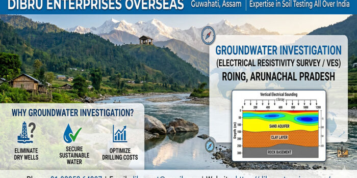
The verified data is sent directly to our primary engineering center in Guwahati. Using advanced geophysical inversion algorithms, we generate a multi-layered model of the subsurface. This model defines the precise depths of the soil cover, the thickness of loose boulder or gravel beds, the location of water-bearing fractures, and the depth of the solid bedrock basement.
Integrating Geotechnical Insight: The Soil Testing Advantage
Groundwater movement is entirely governed by the physical properties of the surrounding soil and rock formations. Because Dibru Enterprises Overseas maintains extensive expertise in comprehensive soil testing services across India, we bring a distinct engineering advantage to every groundwater exploration project.
An accurate assessment of soil grain size, compaction, permeability, and shear strength dictates how water travels through the ground and recharges deeper aquifers. For instance, understanding the ratio of sand to clay helps us predict whether an aquifer will provide a sustainable yield or clog up with fine silt over time. Furthermore, our geotechnical background allows us to evaluate the structural stability of the upper soil layers. This critical insight ensures that when we recommend an optimal drilling location. We also provide guidelines on the required casing depths to prevent borehole collapse during construction.
Strategic Value of VES Surveys Prior to Well Construction
Allocating a fraction of your project budget to a professional geophysical survey yields massive technical and financial returns for any development in Naharlagun:
- Eliminates Blind Drilling: Drastically lowers the financial risk of drilling costly “dry holes” in unpredictable foothill and rocky environments.
- Optimizes Drilling Budgets: Determines the exact required depth of the well, allowing developers to secure accurate drilling contracts rather than paying for open-ended footage.
- Informs Structural Well Design: Identifies the precise boundaries of loose sand, gravel, or boulder zones, showing engineers exactly where solid protective casing pipes must be installed.
- Protects Long-Term Yield: Ensures the well taps into a continuous, major aquifer system rather than a small, isolated perched water pocket that will dry up after a single season.
Comparative Overview of Subsurface Environments in Naharlagun
| Subsurface Zone | Dominant Materials | Hydrogeological Potential | Core Geophysical Challenge | Recommended Drilling Method |
| Alluvial Valley Plains | Sand, silt, rounded gravel, clay lenses | High to moderate; extensive aquifer networks | Differentiating between conductive clay and water-yielding sand/gravel beds | Reverse Circulation Rotary or Mud Rotary Drilling |
| Foothill Boulder Beds | Large quartzite/sandstone boulders, loose soil | Moderate; highly unpredictable water pockets | Extremely high contact resistance due to surface air gaps between boulders</td> | Odex/Symmetrix Drilling (Overburden Drilling System) |
| Elevated Rocky Ridge | Slaty shale, hard sandstone, fractured bedrock | Low to moderate; strictly confined to structural cracks | Locating narrow, vertical fracture zones with surface-based horizontal lines | Down-the-Hole (DTH) Hammer Drilling |
Supporting Naharlagun’s Urban and Commercial Expansion
From the commercial zones along the NH-415 highway to new housing colonies and institutional expansions near the railway station, Naharlagun is growing at an unprecedented pace. Large-scale commercial developments, hotels, automotive workshops, and manufacturing units demand a massive, uninterrupted supply of clean water.
Relying entirely on erratic municipal supplies or expensive water tankers creates major operational vulnerabilities and drives up overhead costs. Establishing independent, high-yield onsite borewells provides commercial properties with total operational security. By leveraging our specialized VES services, you can design water infrastructure that remains resilient across all seasons.
Why Partner with Dibru Enterprises Overseas?
We work with a regional team that possesses a deep, practical understanding of Northeast India’s challenging geography. While our corporate headquarters is located in Guwahati, Assam, our operational footprint extends directly into the rugged terrains of Arunachal Pradesh.</p>
Built for the Terrain
Our field gear, transportation logistics, and safety protocols are customized specifically to handle the steep inclines, heavy rains, dense vegetation, and remote access routes common to Naharlagun. This geographical proximity allows us to deploy field crews quickly and maintain seamless, hands-on project management from start to finish.
Engineering-Grade Documentation
We do not deliver vague, hard-to-read summaries. Our clients receive comprehensive, professional engineering reports detailing calculated layer resistivities, interpreted lithological cross-sections, explicit depth recommendations for drilling, and practical advice on well construction and casing installation.
Comprehensive Engineering Capacity
Our established track record in large-scale soil testing and geotechnical investigation across India. Whether you are a private landowner needing a single residential borewell point or an infrastructure firm managing a major industrial development we deliver the technical precision required to secure your water supply.</p>
Initiate Your Geophysical Assessment
Protect your upcoming infrastructure investments from the risks of unpredictable subsurface conditions. Let our expert team provide the scientific data validation your project needs to succeed.
Contact Dibru Enterprises Overseas today:
Discuss your site specifications, obtain a detailed technical quote, or arrange an on-site field survey in Naharlagun.
- Corporate Base: Guwahati, Assam
- Direct Helpline: +91 93952 64997
- Engineering Inbox: dibru.ent@gmail.com
- Official Website: https://dibruenterprises.com/
Related Posts

This Post Has 0 Comments