

Groundwater Investigation (Electrical Resistivity Survey / VES) Services in Namsai, Arunachal Pradesh by Dibru Enterprises…
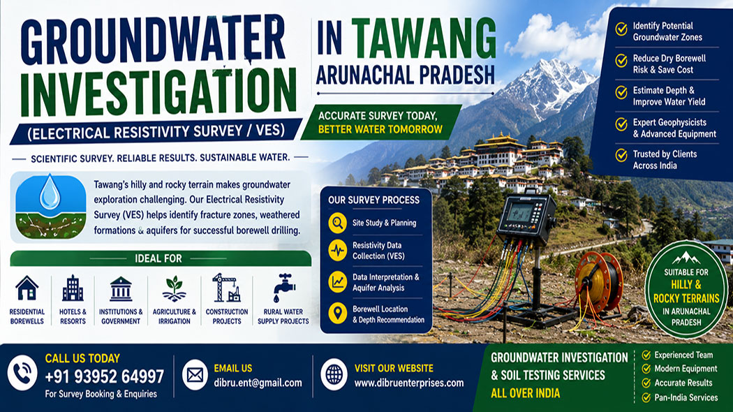
Groundwater Investigation in Tawang: Electrical Resistivity Survey (VES)
Navigating High-Altitude Aquifers: Advanced Electrical Resistivity Surveys (VES) in Tawang, Arunachal Pradesh
Locating dependable underground water sources in high-altitude mountain environments presents an extraordinary challenge for engineers, civic planners, and project developers. Tawang, situated at an elevation of approximately 3,048 meters (10,000 feet) in the northwestern corner of Arunachal Pradesh, is characterized by its dramatic alpine topography, steep ridge systems, and complex structural geology. Unlike the predictable, sprawling sand aquifers found in lowland river valleys, water distribution in this mountainous district is heavily dictated by localized structural features, glacial drift deposits, and freezing temperatures. Relying on guesswork or traditional water-dowsing techniques in this terrain frequently results in dry boreholes, fractured drilling equipment, and wasted capital.
Dibru Enterprises Overseas, operating from Guwahati, Assam, provides specialized geotechnical engineering, comprehensive engineering geology, and high-precision geophysical exploration across India. Our technical teams are fully equipped to deploy advanced Vertical Electrical Sounding (VES) methodologies tailored specifically to handle the rugged, frost-prone subsurface environments of the Eastern Himalayas. By integrating localized geological experience with robust data interpretation software, we assist clients in identifying highly productive water-bearing zones amidst the challenging mountain scapes of Tawang.
Importance of Sustainable Groundwater Management
Mountain ecosystems remain environmentally sensitive. Unplanned groundwater extraction can affect local water balance and natural recharge systems.
Scientific groundwater investigation supports sustainable usage by:
- Identifying suitable extraction zones
- Preventing unnecessary drilling
- Improving water resource planning
- Reducing environmental impact
- Supporting long-term water availability
Proper groundwater assessment becomes increasingly important as infrastructure and tourism activities continue expanding in Arunachal Pradesh.
The Geophysical Science Behind Vertical Electrical Sounding (VES)
The Electrical Resistivity Survey operates on the principle that different subsurface geological materials conduct electricity with varying degrees of efficiency. Clean water stored within porous earth formations drastically reduces electrical resistance, whereas compact, unweathered rock formations stand as major barriers to electrical current. By systematically measuring these variations from the surface, geophysicists can map out a detailed profile of the hidden layers below without turning a single shovel of earth.
Our field protocol utilizes an array of four steel electrodes driven firmly into the ground surface along a predetermined straight line. The outer pair of electrodes is responsible for injecting a controlled, low-frequency electrical current deep into the earth’s crust. Meanwhile, the inner pair of electrodes measures the resulting drop in electrical potential across the site. This raw voltage reading, when combined with the specific spatial geometry of the electrode layout, allows our system to calculate the apparent resistivity of the underlying strata.
To explore deeper geological horizons without physically relocating the equipment, our technicians expand the spacing between the current electrodes outward from a centralized station. Increasing this distance forces the electrical current paths to loop deeper into the earth before returning to the surface. The resulting data points are processed using mathematical inversion modeling programs, which transform raw resistance numbers into true depths, structural thicknesses, and exact lithological classifications.
Analyzing Tawang’s High-Alpine Geomorphology: Cliffs, Moraines, and Permafrost
The distinct geological evolution of the Tawang region requires an adaptable approach to field exploration. The landscape is a mix of ancient metamorphic foundations, loose glacial debris, and active steep valleys, meaning field techniques must change dramatically based on the specific zone being surveyed.
Probing Fractured Metamorphic Bedrock and Granitic Ridges
The core structural foundation of Tawang consists largely of high-grade metamorphic rocks belonging to the Higher Himalayan Crystallines, dominated by biotite gneisses, schists, and hard granitic intrusions. In these massive rock formations, primary porosity is practically non-existent, meaning water cannot seep through the solid stone itself. Instead, groundwater travels exclusively through secondary structural openings, such as tectonic fault lines, rock joints, relief fractures, and weathered shear zones.
Locating these narrow vertical or inclined water conduits requires precise electrode placement. If an electrode line runs perpendicular to a deep vertical fracture, the anomalous low-resistivity signature might be completely smoothed out or missed in the final data plot. Our field engineers solve this by conducting multiple crossing profiles, matching the orientation of our electrode arrays with the known tectonic stress lines of the mountain block to capture these hidden water pathways.
Scanning Glacial Till, Moraines, and Unconsolidated Scree Slopes
Many developed areas, military installations, and tourism pockets in Tawang are built upon thick accumulations of loose slope debris, ancient landslide zones, and glacial moraines. These formations represent a chaotic mix of huge, hard boulders suspended within a loose matrix of rock flour, fine silt, and coarse mountain gravel.
From an exploration standpoint, these unsorted mixtures are notoriously difficult because dry boulder heaps create massive electrical contact resistance at the surface. The electrical current can scatter erratically through the voids between dry rocks, preventing the signal from reaching deeper targets. To counter this structural barrier, our teams use specialized high-voltage power packs to drive the signal through the dry upper debris. We also saturate the ground surrounding each metal rod with saline-bentonite solutions to maximize electrical connectivity.
Accounting for Seasonally Frozen Ground and Permafrost Effects
At Tawang’s extreme elevations, the topmost layers of soil experience deep freezing during the harsh winter months, with true permafrost zones existing at even higher ridges. Frozen water behaves very differently from liquid water; ice acts as an electrical insulator, causing apparent resistivity values to spike dramatically in the upper soil layers.
This frost layer can easily mask the presence of fluid groundwater sitting directly underneath it. An inexperienced surveyor might misinterpret a highly resistive frozen topsoil layer as a deep bed of solid granite, missing a shallow aquifer entirely. Our analysis models utilize temperature-compensated inversion algorithms, allowing us to mathematically isolate the high-resistance frost crust and clearly see the active, liquid water zones moving through the unfrozen depths below.
Adaptations in Field Methodology Based on Specific Terrains
| Specific Terrain Zone in Tawang | Primary Subsurface Material | Hydrogeological Water Target | Main Technical Challenge | Engineering Field Adjustment |
| High Metamorphic Ridges | Hard biotite gneiss, granite, mica schist | Secondary fractures, joints, and tectonic faults | Extreme surface slopes; setting up long straight electrode spans | Utilizing tight, compact array variations; aligning setups parallel to regional fault lines |
| Glacial Moraines & Valleys | Loose boulders, gravel, silty mountain rock flour | Perennial aquifers trapped beneath heavy rocky debris | Extremely high surface resistance; erratic current scattering | Applying saline-bentonite mud to rods; deploying high-voltage power units |
| Thick Weathered Topsoil | Silty clay mixtures, decaying organic matter | Shallow seasonal water tables; perched springs | Confusing conductive clay layers with true freshwater aquifers | Implementing cross-over curve matching; verifying data against local spring flows |
Step-by-Step Technical Execution for Tawang Projects
Dibru Enterprises Overseas implements a rigorous, multi-tiered data acquisition framework designed to withstand the environmental and physical pressures of high-altitude Himalayan field operations.
- Geological Desk Study and Satellite Alignment: Our engineering office begins every assignment by analyzing structural data, regional lineaments, and hydrogeological maps provided by the Central Ground Water Board (CGWB). This desk study allows us to map out major regional fault lines before our crew even arrives at the site.
- Terrain Reconnaissance and Safety Assessment: The field crew surveys the property on foot to clear an optimal layout path. We carefully map out routes that protect our technicians from steep drop-offs and keep our long, sensitive cables far away from local power grids or heavy machinery loops that could cause electrical interference.
- Electrode Array Calibration: We typically utilize the Schlumberger array configuration for deep structural mapping, though we transition to the Wenner array when fine-grained shallow detail is required for foundations. Each metal electrode is driven deeply into the mountain soil using heavy sledgehammers to ensure solid physical placement.
- Signal Stabilization and Measurement: Our modern digital resistivity equipment sends alternating current pulses into the ground crust. The system uses real-time statistical processing to filter out natural background earth currents, compiling clean, repeatable voltage values even in harsh alpine weather conditions.
- Geoelectrical Inversion Modeling: The processed field curves are fed into powerful computer optimization software. This system generates a detailed, multi-layered cross-sectional model of the earth, highlighting the exact depths, thicknesses, and water saturation levels of the underlying formations.
- Drilling Site Selection and reporting: We deliver a professional, easy-to-read engineering report that clearly outlines our findings. This comprehensive document removes the guesswork from your project by providing clear, actionable coordinates for your drilling team, showing them exactly where and how deep to drill to secure a high-yield well.
Future Importance of Groundwater Investigation in Arunachal Pradesh
Rapid infrastructure growth, tourism expansion, and increasing water demand are creating greater need for scientific groundwater exploration in Arunachal Pradesh.
In mountainous regions such as Tawang, proper groundwater assessment helps:
- Improve water security
- Reduce failed drilling
- Support infrastructure growth
- Enhance rural development
- Promote sustainable resource management
Geophysical surveys will continue playing an important role in future water resource planning across the Northeast.
Importance of Groundwater Investigation in Tawang
Tawang lies in the western part of Arunachal Pradesh at a high elevation within the Eastern Himalayan region. The district experiences rugged topography, cold climatic conditions, and rocky subsurface formations. Water availability in such mountainous terrain often depends on localized fracture systems and weathered rock zones rather than extensive underground aquifers found in plains.
Traditional borewell drilling methods without scientific investigation may fail due to:
- Compact hard rock formations
- Limited groundwater storage zones
- Steep terrain conditions
- Uneven groundwater distribution
- Seasonal recharge variations
- Fracture-controlled water occurrence
Electrical Resistivity Survey helps identify subsurface formations capable of storing and transmitting groundwater before drilling operations begin.
Why Choose Dibru Enterprises Overseas for Your Tawang Operations?
Partnering with an experienced, fully equipped engineering company ensures your high-altitude project yields reliable data, saving you from costly structural mistakes and dry boreholes.
Exceptional Regional Hydrogeological Expertise
Operating out of our central office in Guwahati, Assam, our field engineers have spent years managing complex geotechnical challenges across the diverse landscapes of North East India. We understand the specific behaviors of Himalayan rock systems, structural fault zones, and alpine water cycles. This deep local experience gives us a significant advantage over outside firms that may struggle to adapt to the rugged environments of Arunachal Pradesh.
Advanced High-Power Instrumentation
We do not use low-power or basic consumer-grade equipment that fails when encountering thick boulder fields, dry mountain scree, or frozen topsoils. Our teams utilize high-output, professional-grade digital resistivity meters designed to deliver stable, clean readings through highly resistant mountain layers. Our software allows us to identify narrow, water-rich rock fractures that basic systems miss entirely.
Nationwide Engineering and Soil Testing Capabilities
Beyond our advanced groundwater exploration services, Dibru Enterprises Overseas provides top-tier soil testing, structural drilling, rock coring, and foundational site analysis throughout India. Whether you are developing a major infrastructure project, establishing a remote military station, building a commercial tourist property, or setting up a rural water supply grid, we provide a complete, dependable suite of ground engineering services tailored to your needs.
Connect with Our Technical Engineering Team
Protect your upcoming drilling or construction project from unexpected subsurface failures. Partner with a trusted team of engineering geologists who know how to successfully navigate the complex, high-altitude terrain of Tawang. Contact Dibru Enterprises Overseas today to discuss your site requirements, receive a transparent cost estimate, or book an on-site subsurface survey.
- Corporate Headquarters: Guwahati, Assam, India
- Direct Phone Contact: +91 93952 64997
- Official Email Address: dibru.ent@gmail.com
- Corporate Website: https://dibruenterprises.com/
Conclusion
Groundwater exploration in Tawang requires scientific methods due to the region’s rocky terrain, steep topography, and fracture-controlled groundwater systems. Electrical Resistivity Survey and Vertical Electrical Sounding provide reliable solutions for locating potential groundwater zones before borewell drilling.
Professional investigation helps reduce financial risk, improve drilling success, and support sustainable water management in mountainous environments. With expertise in groundwater investigation and soil testing services, Dibru Enterprises Overseas offers dependable geophysical survey solutions for projects across Arunachal Pradesh and throughout India.
Related Posts

This Post Has 0 Comments